Learn about online mapping for your classroom!
Catch a POSTER or PRESENTATION
- Tuesday, Feb. 7th, 9:00am, Poster Pavilion, “Where, Why, Who, What, How: Data and Online Mapping”
- Wednesday, Feb. 8th at 3:30pm, Room 8AB, “We All Have a Story to Share: Engage and Inspire All”
Visit the BOOTH
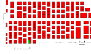
Visit the Esri Booth. Pickup free curriculum materials. Learn about the free online mapping available for schools. Find some cool buttons or books that you need.
| Tuesday, February 7 | 3:00 p.m. – 6:00 p.m. |
| Wednesday, February 8 | 9:00 a.m. – 5:00 p.m. |
| Thursday, February 9 | 9:00 a.m. – 5:00 p.m. |
2210

Visit the GeoSIG Playground
Don’t miss this chance to ask questions, play with the technology and get your classroom plugged into GEO!
Bring yourself and a friend! Get charged up at the GeoSIG Power Mapping Playground! Come play with maps, ask questions, get more information and power up your classroom to go to the next level!! Come for 30 minutes… come for two hours!
Tour our interactive stations:
- Drones and Creating Imagery – (No drones will be flown)
- Make a Map – (Or the RQB [Random question booth])
- GeoInquiries – 15-minute online mapping activities for U.S. History, Elementary, AP Enviromental, AP Geography, Earth Science…also learn about other subjects coming soon.
- StoryMaps – Crowdsource / Journal / Cascade
- Collecting and Visualizing Data – Survey 123 to Map, Snap to Map, and more
Get your GeoPassport punched at least 5 times and enter your name in the door prize drawing. (do not need to be present to win)
Plug into MAPS
Read our TCEA blog article about GeoSIG and the cool map options for you.

