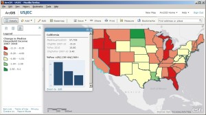
We are friends with and big fans of Charlie Fitzpatrick from Esri. Today, we are sharing one of his great tips on how to create maps that can help students recognize and understand data through maps. Be sure to follow the link at the end of this excerpt to read his full article!
 “ArcGIS Online provides great maps easily. Teachers and students alike take only seconds to start making and saving their own maps. But is there any way to use interesting data from the morning paper, or an old data set from previous activities? You can engage these if (a) you understand enough about shapefile construction to change a database, and (b) you have a shapefile to which you can match your external data. You can do a lot even without having full desktop GIS tools or skills!
A new ArcLesson details the process: “Using External Data Tables with ArcGIS Online.” It walks through exploring the components of a shapefile, exploring the design of the database, editing the database (using Open Office), and testing the results. A sample shapefile of the 50 US states is provided for practice. The fundamentals are simple, and the results impressive.”
At GISetc.com we curate and bring you the best geography and science resources from the web. We hope our sharing will keep you up to date on the latest science and geospatial news.
