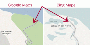
 Google Maps and Google Earth is a wonderful tool that has brought mapping and geography back into the public eye in a big way. I do believe that using the right tool for the right job should be our mantra. In this particular case, in our humble opinion, using a GIS (geographic information system) would have been the more likely tool to use to get the correct boundary.
“A Nicaraguan military commander, relying on Google Maps, moved troops into
an area near San Juan Lake along the border between his country and Costa
Rica. The troops are accused of setting up camp there, taking down a Costa
Rican flag and raising the Nicaraguan flag, doing work to clean up a nearby river,
and dumping the sediment in Costa Rican territory.”
